Document Author
Topic
- (-) Remove About Cartography filter About Cartography
- Map Gallery (8) Apply Map Gallery filter
- 100% Access to Justice (2) Apply 100% Access to Justice filter
- Justice Tech Entrepreneurs (2) Apply Justice Tech Entrepreneurs filter
- Strategic Planning (2) Apply Strategic Planning filter
- Working Groups (2) Apply Working Groups filter
- Consumer Adoption (1) Apply Consumer Adoption filter
- Integration with Institutional Process (1) Apply Integration with Institutional Process filter
- Research (1) Apply Research filter
Region
- (-) Remove United States filter United States
Tags
Post date
Search results
Webinar: Mapping Access to Justice: Success Stories and Lessons Learned from the Field Featuring The Florida Bar Foundation (SRLN 2017)
NOTE: This video can be viewed at any time by registering at the link below. The Self-Represented Litigation Network (SRLN) is hosting this Webinar to share the story of how The Florida Bar Foundation used geographic information systems (GIS) technology ...
Presentation: GIS for Justice Workshop with Tip Sheet for GIS Analysis (NLADA 2017)
" GIS for Justice: Using a Tools from Outside the Lawyer's Toolbox " As we work collectively to fulfill the promise of justice for all and transform disadvantaged and disenfranchised communities, maps and visual data can be critical to our ...
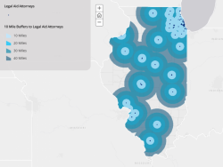
Presentation: Know Your Users- The Importance of User Experience in Court Planning and Operations (Court Technology Conference 2017)
The Illinois Supreme Court and SRLN created a mapping application to assess the court user's experience in Illinois. “User experience and thinking about our users helps increase efficiencies, helps us know what we don't know, and helps us better ...
Presentation: What’s In It For Me? How to Use Geospatial Data Visualization to Inform and Engage Decision Makers (EJC 2017)
At the 2017 American Bar Association (ABA) Equal Justice Conference and the National Meeting of State Access to Justice Chairs, Nancy Kinnally and Alison Davis-Holland shared their story of how they used geospatial data visualization and strategic messag ...
Resource: What a Geographic Information Systems Is and What it Can Do (Davis-Holland 2016)
Alison Davis-Holland's GIS with a Test Drive presentation, offered as a slideshare, highlights the top ten functions that GIS can do and uses simple language to explain the capabilities of GIS and spatial analysis. The presentation provides real worl ...
Resource: GIS/Data Resources for Justice (SRLN 2017)
Geographic Information System (GIS) technology and data can provide useful information to drive decision making in the justice community. Here are some resources that can help. Data Geospatial datasets at data.gov ArcGIS Online Census Bureau's Amer ...
Article: Choose the Right Map Symbology To Make Your Story Shine (Davis-Holland 2018)
Think cartography is all stats and science? Prepare to be surprised by the amount of psychology, art, design, culture, and communication involved in map making and how to choose effective symbology that makes your story and data shine. Great read for thos ...
Webinar: GIS Day! Geo-enable to Bring Data to Life for Justice (SRLN 2016)
In coordination with GIS Day and National Geographic's Geography Awareness Week, the Self-Represented Litigation Network (srln.org) has hosted and recorded a webinar on some of the ways geographic information systems (GIS) technology is being used t ...